I enjoyed my Italy trip immensely. On this trip I graduated to the realm of the connected-passenger, relying on technology to assist my travels. I thought I’d share some of the apps that I found useful (and a couple I didn’t). Also, note that I have an iPhone, so I can’t comment on the availability of the apps for other phone types.
International data plan: Before setting off, do take the time to research your wireless phone provider’s international plan options. Mine has a day-pass for $10/day which essentially extends the already generous cellular voice/data limits of my existing plan to use while connected in other covered countries. Free wifi is generally widely available in Europe, but I found it could be a bit spotty. I didn’t want to worry about data caps, and Italy and the U.K. are included in my provider’s per-day international plan, so I went with that. You may choose differently, but decide before you leave.
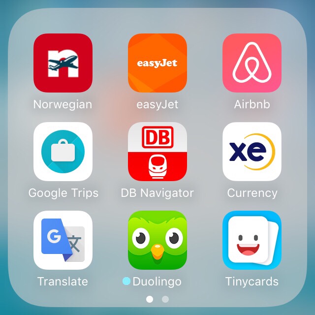
Airline apps: This trip I flew Norwegian Air Shuttle and easyJet. You’ll want your airlines’ apps on your phone, too. Online check-in may help you avoid some lines, and online boarding passes can make connections and terminal transfers a bit easier without having to find a kiosk or person to print out a paper boarding pass for you.
Lodging: I booked my lodging through Airbnb. The Airbnb app makes for easy communication with hosts for directions, check-in times, and handling any questions or problems that come up during your stay. If your hotel has an app, you may want to install it for the same reasons.
Itinerary management: Instead of printing out a dozen or so reservation details, I opted to use GoogleTrips to integrate them all together. Once installed, you can login and have it pull details from emails in your inbox relating to travel reservations, and it will organize them all neatly by trip, date, and destination. And you can have it download the itinerary for offline viewing. This puts times, flight numbers, locations, reservation codes, contact details in one easy to reach place.
Train schedules: Following a tip from Rick Steve’s Europe website, I installed the Deutsche Bahn’s app DB Navigator for online rail timetables. It was awesome. Though it is the German rail’s app, it includes very current schedules for all of Europe for online viewing. The Italian rail information was accurate and I used this app exclusively to plan my train travel. I didn’t use it to purchase tickets, just to figure out which train I wanted to catch. I highly recommend it.
Currency conversion: The Xe currency app works online, or offline if needed, using the last exchange rate it downloaded. Not necessary but nice to have if you don’t know how much that thing is really going to cost you.
Foreign language help: My English and Spanish get me by in most places, but I don’t know much Italian. So, I used the Google Translate app. It will translate individual words or phrases for you. But it can also use the camera on your phone and will translate entire paragraphs of text in an image for you. This was awesome for translating text from tour brochures. Plus it was just kind of fun to use.
I also recommend Duolingo for learning a new language. I always have it on my phone, to sharpen my Spanish, and I used it for a few weeks ahead of my recent trip to learn a bit of Italian. It definitely helped. They also make a flash card-based app called Tinycards that is a nice companion to the original Duolingo app. And they are both free.
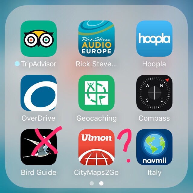
What to see: I installed the Trip Advisor app, and downloaded ahead of time the info they have on Florence, Pisa and Cinque Terra. I used it to look for ideas on new things to see and places to visit. Google Trips also has a “things to do” category, but I found Trip Advisor was the one I used more.
Finally, I recommend installing Rick Steve’s Audio Europe app. It has audio walking tour and museum audio tours for several destinations in Europe. You can download ahead of time the ones you want to listen to.
Entertainment: I always tote my kindle e-reader around, but I also downloaded some free audiobooks and videos using Hoopla and Overdrive apps. If your city library participates with them, you can checkout several titles for free each month. I loaded up a few for the plane and train rides.
I never leave home without my Geocaching app. If you want to see more than a few caches you’ll have to sign up for a premium membership, which I find very reasonable. You can download ahead of time collections of caches in different places that you are going to visit. I earned my Italy badge on this trip. Woohoo! I carry a real compass in my backpack, but an electronic version is handy, too.
I left my binoculars and big camera at home this trip. So I didn’t think I’d get much birding in, and that was correct. I could hear many birds, but I was hard-pressed to get a good look at most. Before I left, I paid $15 for a European birding field guide app called Collin’s Bird Guide, as the European bird species are different from those in North America. Turns out I didn’t use that app at all. It has beautiful content, but I wouldn’t recommend it. It didn’t have a function to guide me in identifying a bird by color, size, etc. Good old Google search did the trick; I’d search, for example, on “Italy large black and grey bird” and just scroll through pictures until I found the one I was looking for. A website called world-birds.com turned up often with helpful info.
Navigating: I prefer paper maps, but for electronic aid I just used Google Maps to plot walking directions ahead of time, or if I had a “where the heck am I” moment. I wasn’t worried about my data usage as my data plan has high limits. But if you are, you can look up a route and directions while on wifi and take a series of screen shots ahead of time for viewing later. There are a couple other map/navigation apps I’ve seen recommended, but I didn’t use them: navmii and CityMaps2Go. If you really are trying to limit your data usage while traveling, download these ahead of time to see how helpful they are and practice with them before you leave.
Check out these and other apps to make your trip more enjoyable.
What other apps would you recommend?


